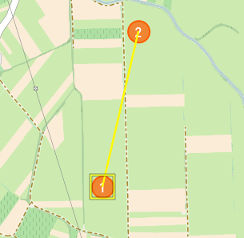
Waypoint is the position in physical space where UAV will change the direction, speed or altitude along the desired path. For air navigation waypoint coordinates include longitude, latitude and altitude.
 Waypoint. |
Flight plan is created by adding waypoints to the map. Draw section explains different ways of adding waypoints. |
WARNING: If waypoint altitude above ground level (AGL) becomes too low Ground proximity warning markers will appear around the point.
 Flight Line - UAV flies from the 1. Waypoint to the 2. Waypoint following the flight line. |
Flight line specifies the trajectory followed by the UAV to reach destination Waypoint from the preceding one. Click on the Waypoint point and move it to the desired position. |
NOTE: Newly added waypoints use parameters set in Mission Settings dialog. Individual waypoints (WAY PTS menu) can be also modified through the dialog shown in the picture below.
Double-click on the waypoint (or select a row in the Flight Plan table) to open the settings dialog.
Waypoint parameters are settings used by the autopilot in navigation mode. These settings are uploaded to the autopilot using Upload Waypoints button. Adjust display units in Settings, Units tab.
Waypoint dialog.
|
Parameter |
Value |
|---|---|
Coordinates |
Enter coordinates of the waypoint (change position). Adjust coordinates format in Settings dialog, Units tab. |
Altitude AGL |
Min: Equals Minimum Height Above Ground setting. Max: 3000 m setting. |
Air speed |
Min: Value depends on the selected airframe. Max: 22 m/s |
Loiter radius |
Min: 0 m Max: 3000 m |
Loitering time |
Min: 00:00:00 h/m/s Max: 03:00:00 h/m/s |
Altitude MSL |
Mean Sea Level altitude value of a waypoint. |
Fly to |
Sets current waypoint as UAV's desired target. Fly To command is automatically uploaded to UAV. NOTE: Available during the flight |
Flight direction |
Defines the direction of the UAV during loitering (clockwise or counter-clockwise) |
Direct antenna to Available with antenna tracker connected |
Directs antenna tracker towards selected waypoint coordinates. NOTE: Used when UAV's control is taken over between multiple GCSs. When UAV is approaching and the communication is not yet established the button will be available. Once antenna tracker is oriented towards the approaching UAV and the communication is established the button will be hidden from the dialog. |
Waypoint parameters.
If waypoint altitude above ground level (AGL) becomes too low Ground proximity warning markers will appear around the point.
WARNING: Terrain elevation should be checked on a topographic map. In some cases DEM does not have correct values or any values (when flying outside of the covered area) which can lead to an unsafe situation. If this is the case you should adjust altitudes of waypoints in Mission Settings/Waypoints dialogs according to the information from topographic map.
