Two options are currently available for elevation data.
When ASTER GDEM 2 (Global Digital Elevation Model Version 2) is selected for use it is automatically downloaded from C-Astral servers for currently viewed location and saved locally on the computer hard drive. ASTER GDEM coverage spans from 83 degrees north latitude to 83 degrees south.
When SRTM GL 1 (Shuttle Radar Topography Mission Global 1) is selected for use it is automatically downloaded from C-Astral servers for currently viewed location and saved locally on the computer hard drive. SRTM GL1 coverage spans from 60 degrees north and 56 degrees south latitude. Voids have been filled with ASTER GDEM 2.
WARNING: Terrain elevation should be checked on a topographic map. In some cases DEM does not have correct values or any values (when flying outside of the covered area) which can lead to an unsafe situation. If this is the case you should adjust altitudes of waypoints in Mission Settings/Waypoints dialogs according to the information from topographic map.
 Elevation not available |
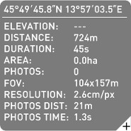
Elevation is downloaded for the currently visible map portion. Zoom out as well as moving of the map will trigger download of new elevation tiles. If download was successful you will see elevation data displayed on the Mission Data panel. If download fails (no Internet connection, DEM does not exist for the desired location) Elevation field on Mission Data panel will be empty showing Elevation: "---" and you will see warnings about missing elevation data on Log panel. |
We strongly advice to check that elevation data is available on the computer you are going to fly with. Connect to the Internet while in the office and zoom out the map enough to trigger downloading of all elevations you might need. Downloading of elevations can take some time, which depends on the zoom level of the map. Check that all elevations are available by moving the mouse over the map. Check waypoints altitudes in the Flight Plan table.
If you are not able to download elevations please contact the C-Astral support team.
