Once you know the terrain you are going to map and its characteristics (for example you should be familiar with the height of the surrounding hills, buildings, trees and the vicinity of the water as well) you can start to plan your flight.
The flight plan is a sequence of flying stages (modes), such as take-off, navigate and land. Each stage has the relevant parameters that define the behavior of the UAV, like the flying altitude, speed and the trajectory it follows.
NOTE: Learn about take-off mode in Home and Take-Off chapters. Learn about landing mode in Rally and Parachute chapters. Learn about navigation mode in Draw chapter.
 Flight Plan Table |
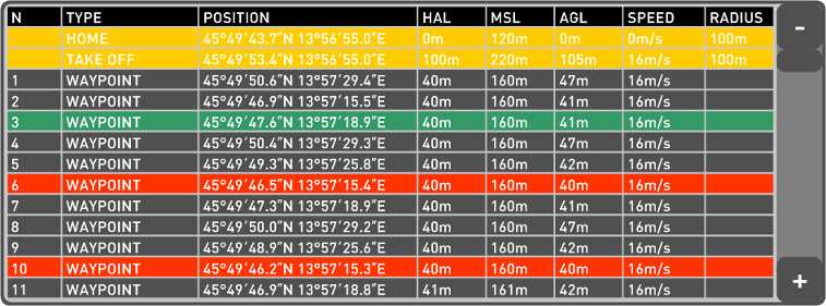
Click on the FLIGHT PLAN TABLE button to open the table with a list of waypoints. When you are creating a flight plan you are positioning Home, Take-off, Rally, Parachute/Land points and Waypoints on the map. Parameters of these points (which are commands uploaded to the autopilot) are displayed in the Flight Plan table. |
oDestination and currently selected waypoint row is highlighted with green color.
oWaypoints with AGL values that are the same or lower than the Min HAG value are highlighted with red color.
 Flight Plan Table - List of waypoints with parameters. |
Column |
Description |
|---|---|
Type |
Type of the point (autopilot command). |
Position |
GPS Latitude and Longitude Coordinates of the point. |
MSL |
Mean Sea Level altitude value of the point. See relative/absolute altitude mode. |
AGL |
Above Ground Level altitude of the point. See relative/absolute altitude mode. |
Speed |
Air-speed of the UAV. |
Radius |
Loiter radius around the selected point. |
Flight plan - list of waypoints.
NOTE: Click on the table row opens selected waypoint dialog. Parameters can be edited for the waypoints that are drawn using WAY PTS menu.
