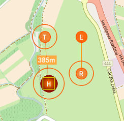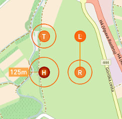
Home point is the position of the UAV in the moment when the GNSS lock is acquired. Home position is also the position to which the UAV flies in case the Failsafes are triggered (Loss of Communication and Low Battery level Failsafes) and must be located in the place where you can easily retrieve the UAV.
 Home |
Home position is locked during the pre-flight phase and cannot be moved to some other location on the map. The UAV is launched from this position. After take-off Home point can be moved. |
WARNING: Position of Home point can be changed during the flight. Consequently, the launch point and the Home point will have different coordinates and mean sea level (MSL) altitudes. Height above launch (HAL) value of the Home point will be no longer 0 m but some positive or negative value, depending whether the point is moved to the higher or lower position relative to the launch point.
 Home - Move the marker to change H point position. |
Click on Home point and move it to the desired position or place Home point through the context menu. Home position is uploaded to the UAV autonomously each time Home point is moved. |
 Home - Change loiter radius. |
Select the circle around Home point and drag it to change its radius. Once the communication between C³P and the UAV is established the change of radius will trigger Upload Waypoints button to start blinking. After Upload Waypoints button is pressed new loiter radius will be uploaded to the UAV. IMPORTANT: Changing of Home loiter radius while in Home mode has no effect on the current UAV flying path. You can update it while in Home mode but in order for change to take effect you must switch to some other mode and go back to Home mode. This is the limitation of the current autopilot. |
Parameters
Home parameters are settings used by the autopilot in Home mode. These settings are uploaded with the flight plan using Upload Waypoints button. Adjust the parameters as described in the above chapter Home Position. Adjust display units in Settings, Units tab.
WARNING: Terrain elevation should be checked on a topographic map. In some cases DEM does not have correct values or any values (when flying outside of the covered area) which can lead to an unsafe situation. If this is the case you should adjust altitudes of waypoints in Mission Settings/Waypoints dialogs according to the information from topographic map.
NOTE: UAV will return to home with MIN GO HOME altitude set in Failsafes. C3P constantly calculates safe MSL altitude, according to predefined AGL setting, that UAV can use to return home. If current altitude is higher than calculated one the UAV will return back home with same altitude.
